

SIOUX FALLS — The National Weather Service is warning of critical fire danger across eastern South Dakota as low relative humidities and dry fuels are forecast from Friday into next week.
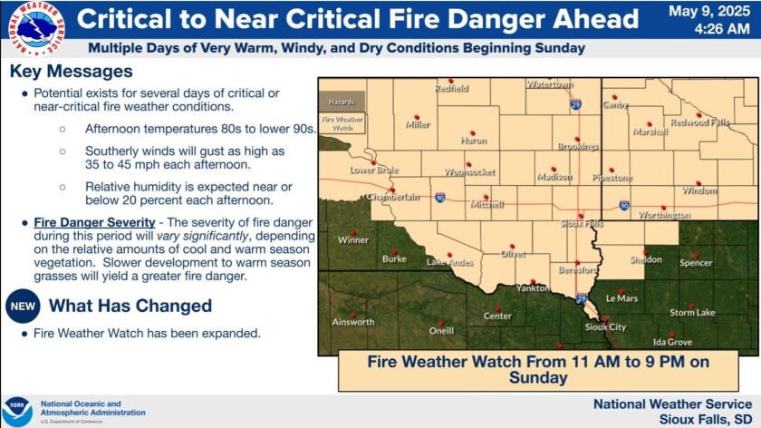
An urgent fire weather message was issued by the National Weather Service in Sioux Falls on Friday, May 9, covering all of East River with the exception of three north-central counties.
Forecasters warn that temperatures in the high-80s to low-90s on Friday, Saturday and Sunday will match with southerly wind gusts of up to 45 mph and relative humidity at or below 20% during the afternoon hours. Those conditions are expected to continue through early next week, resulting in critical fire danger through at least Tuesday.
According to the U.S. Drought Monitor, most of East River South Dakota is abnormally dry, though areas of moderate and severe drought do exist. While the National Weather Service acknowledges that conditions will vary locally, it urges extra vigilance.

Anytime fire danger exists, forecasters and first responders urge the public to avoid burning, if possible, and be mindful of anything that can create sparks, including the disposal of cigarette butts. Any areas with dry grass or vegetation will be susceptible to elevated fire weather conditions.
Isolated to scattered light showers during the late afternoon and evening Friday may also produce stronger erratic winds, with a potential for isolated gusts up to 40 to 50 mph. The greater chances for showers and associated stronger winds looks to be across southwest Minnesota and nearby areas of southeast South Dakota and northwest Iowa.
The urgent fire message isn't unique to eastern South Dakota, as forecasters in eastern North Dakota and all but southeastern Minnesota have issued similar messages. The most current information regarding weather conditions is available by clicking on your region on the National Weather Service's page.
— The West Central Tribune's Kelly Boldan contributed to this article.


